As the sun came up, the mist rose from our anchorage at Cumberland Towhead Island. We hoisted the hook and were on our way.
 As we turned from the Ohio River up into the Cumberland, we looked further up the Ohio to the impressive Smithland Lock and Dam, which was not on our route.
 We think this was a Country Club at Smithland, although from what we could see, there weren’t enough homes along the bank to support it.
 The Cumberland River is much narrower than the Ohio. We get a close-up view of the banks.
  This is an agricultural area, with cattle herds grazing on the hillsides.
 And here’s a gravel pit with a huge dump truck, busily moving the gravel to load on barges on the river.
  Turkey vultures are patiently waiting for something to die. Their heightened sense of smell attracts them to “eau du dead thing!”
  While the quarrying scars the land, this quarry wall is interesting.
  Along the riverbank, erosion washes out the sand, and the trees try to hang on.
  In the tiny town of Dycusberg, Kentucky on the right descending bank, this little church was the centerpiece.
 The only lock we transit on the Cumberland River is the Barkley Lock, which forms the 134 mile-long Lake Barkley. These are named after the 35th Vice President of the United States, Alben W. Barkley. This lock, dam and lake are the responsibility of the US Army Corp of Engineers.
  The lock lifts us 56 feet to Lake Barkley, which was formed in the early 1960s when the adjacent dam was constructed on the Cumberland River. That together with the Kentucky Dam on the Tennessee River, impounded the two rivers to form an inland peninsula bordered by Kentucky Lake and Lake Barkley. This peninsula is called The Land Between the Lakes, and was designated a National Recreation area by President John F. Kennedy in 1963.
 Here are the lock’s double floating bollards, which can be tied to either from an upper or a lower boat deck. As they move up or down with the lock water levels, it simplifies the act of locking through. We appreciate the help!
  While the Land Between the Lakes National Recreation area is mostly parkland, there are a few homes around the town of Grand Rivers. Some are most impressive waterfront homes, as this one, others are mobile homes, and others are everything in between. When the dam formed Lake Barkley in the 1960s, entire communities were removed from the lowlands by eminent domain and relocated to higher ground. Grand Rivers is the only surviving Kentucky “between the rivers” community still in existence, though they sacrificed half of their original land for the new lake.
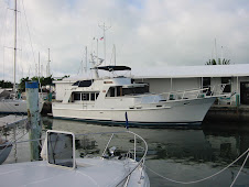
 We found the well marked but narrow entrance to our destination, the Green Turtle Marina. This is the area’s premier marina resort and deep-water harbor with 420 slips, condos, restaurants, health club and indoor pool. We did go for a swim here – the pool water was 85 degrees, which felt good after the cool weather and rain we’ve experience.
 We got a great slip, and decided to stay two nights because of predicted heavy rains. The marina has courtesy vans, and we check one out to make a drive to Paducah, Kentucky, about 35 minutes away. This town is known for the National Quilt Museum and is home to the American Quilting Association.
 We enjoyed our stay here. We dined at Patti’s 1880’s Settlement, a 1970’s era tourist restaurant that can seat 250 diners in numerous over-decorated rooms. The theme now is Christmas, and there wasn’t an inch of wall or ceiling untouched by Patti’s two full-time decorators. They work year-round to execute seasonal themes. But the food was good, with the house specialties a 2-inch thick pork chop, flower-pot bread and mile-high meringue pies. In celebration of our 30th wedding anniversary, we were presented with a mini-cheesecake lit with two candles, and the waitstaff sang “Let Me Call You Sweetheart.”
You can locate us at the following link - http://greatloop.org/mod/aglcalocator/membermap.php?id=1601
You can see all of the locations by clicking on the Looper Log at this site also!